


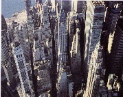


Figure 1. Aerial photograph of iconic Lower Manhattan.
Figure 3. Lower Manhattan and WTC site plan before/after attack of 9/11/2001.
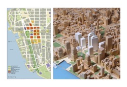
Figure 4. Chart of New York City public spaces: clockwise, Lincoln Center; Grand Central Station; Union Square; Washington Square; Gramercy Park; Rockefeller Center; Bryant Park; and NY Public Library, compared to the World Trade Center site outlined in red.
Figure 5. Empty WTC site model after 9/11.
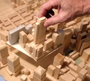
Figure 6. Rockefeller Center model inserted into the site replicating the same 10 million square feet of lost WTC building area.
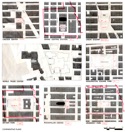
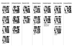
Figure 7. Matrix chart of diverse urban site solutions with differing grid resolutions and open space locations.
Figure 8. Peterson Littenberg Memorial Park project included in the first public presentation, July, 2002.
Figure 9. Peterson Littenberg Memorial Promenade project included in the first public presentation, July, 2002.
Figure 10. New York Post, July 18, 2002, declares: “Twin Towers II” - Memorial Promenade (figure 9) — “overwhelming favorite” after the Town Hall presentation.
Figure 11. Peterson Littenberg project for the Innovative Design Study, the final “Master Site Plan Competition,” December 18, 2002 - September 17, 2003.
Figure 12. Peterson Littenberg model looking down on the Public Garden precinct, surrounding elevated roof gardens, and the new Twin Towers.
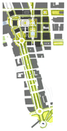
Figure 13. View down proposed West Street Boulevard, looking south toward Upper New York Bay, Ellis Island and the Statue of Liberty.
Figure 14. The staged development of Park Avenue north of Grand Central Station, 1888, the precedent for reconstruction of the WTC site.
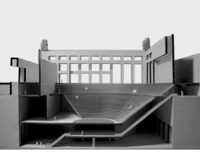
Figure 16. Sectional model of 2,800 seat commemorative amphitheater leading down to the Memorial Museum on the north tower footprint.
Figure 15. Public Garden precinct containing the tower footprints and memorial museum surrounded by streets with future building sites.
Figure 17. The Public Garden Precinct (in yellow) is drawn on the WTC plan to show how the relationship between the original twin towers is maintained.
Figure 18. Sectional perspective through the Public Garden, Greenwich Place with underground pedestrian shopping concourse below, PATH trains, and subway.
Figure 19. View of Saint Paul’s Square located at the north end of Greenwich Place. The tower at its center marks the northeast entry to the underground shopping concourse and mass transit.
Figure 20. Below-grade plan of the pedestrian network (in yellow) linking the lower lobby of the World Financial Center east to the transportation hub on Broadway and the north/south shopping concourse under Greenwich Place.
Figure 21. Skyline with new twin towers showing their staggered placement relative to the World Financial Center in Battery Park City.
Figure 22. Projects compared: Peterson Littenberg, left, and Libeskind, right.
Figure 23. Model view of the Peterson Littenberg final design showing the relationship between the Public Garden and West Street Boulevard.
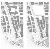
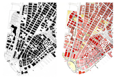
Figure 2. Lower Manhattan Urban Design Plan, 1994, before/after.